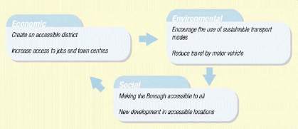
5. Transport
To create an accessible Borough which can attract inward investment and create viable town centres. To promote development in accessible locations so as to reduce the need to travel. Where travel is necessary, sustainable modes of transport should be encouraged.
Policy 29 – CREATING AN IMPROVED TRANSPORT NETWORK
29.1 The following improvements to the road network in Pendle will be supported:
- Construction of a link from Colne to North Yorkshire border.
- One-way system on Langroyd Road, Colne.
29.2 The former route of the Colne-Skipton railway line will be protected for future transport use (see proposals map). Planning permission which would prevent the re-use of the railway route for future road and/or rail will not be permitted.
29.3 A proposed route to the west of Earby is protected as a transport corridor for potential future road development.
29.4 A Transport Assessment and Travel Plan will be required to be submitted for any development proposal that will considerably impact on the capacity/demand of the road network.
29.5 The Borough Council will support Traffic Calming initiatives, particularly in residential areas. Developers seeking new residential, employment, retail or leisure development on land over 0.4 ha (or part of) should provide Traffic Calming measures on site where appropriate, and contributions will be sought for traffic calming initiatives around the development if required.
The Regional Spatial Strategy for the North West (RPG13) states that priority should be given to investment in the maintenance, management and selective improvement of regionally significant highway routes. The RSS recognises that further investment is still required on some sections of the highway network to bring it up to a safe and modern standard, and to provide relief for those communities badly affected by heavy flows of through traffic. Accessibility is vital for attracting inward investment, supporting market restructuring initiatives and creating attractive and viable town centres. The RSS identifies the A56 north-east from the M65 at Colne to North Yorkshire as a route of regional significance.
The Local Transport Plan for Lancashire (2001-2006) states that the main part of the strategic highway network through Pendle is the M65 and A6068/A56 route. The Highways Agency is the Highway Authority for the Strategic Trunk Road. The M65 provides effective motorway links with the M6 and Brierfield, Nelson and Colne. The A6068/A56 route forms a continuation of the strategic route into Yorkshire. Severe capacity problems occur where the M65 motorway ends at Colne, and on the A56, heavy vehicles cause environmental problems in several villages. The Local Transport Plan identifies the need for an A56 Village Bypass. A proposed route (approved by LCC and North Yorkshire County Council after public consultation) follows part of the former Colne to Skipton rail track bed. However, in the JLSP the rail track bed is protected for transport use as opposed to road use only, in light of possible reinstatement of the railway line and guidance contained in RSS for protecting disused rail track beds. This Policy therefore protects the former route of the Colne-Skipton railway line for future transport use – road and/or rail and in addition protects part of the former route of the proposed road west of Earby for transport use. The protected routes for transport are detailed on the proposals map.
The Local Transport Plan seeks to maintain the highway network in a safe condition and to an acceptable standard for all users. As a result Lancashire County Council funds have been made available for a number of improvements. Following the recent construction of a roundabout at the junction of Skipton Road and Byron Road, to further reduce congestion problems, a proposed one-way system is to be implemented on Langroyd Road.
PPG13 requires traffic management measures to be promoted to improve the quality of local neighbourhoods, enhance the street environment and improve road safety. Traffic Calming, in particular 20 mile per hour zones, has been successful at reducing traffic speeds and accidents in Pendle. Lancashire County Council (2004) record a reduction in all road accidents since 1998 in Lancashire as a whole. This policy will support further Traffic Calming schemes, particularly in residential areas, although rural areas will also be targeted through support of the Quiet Lanes initiative, a joint initiative between Lancashire County Council and the Countryside Agency. Traffic calming should form part of any large development (over 0.4 ha gross). The developer of any large (over 0.4 ha or part of) site, irrespective of proposed use, should contribute to traffic calming in the immediate vicinity in an attempt to minimise traffic problems as a result of increased traffic flows. Contributions will be sought through a Section 106 Agreement (Appendix 1). All required contributions should meet the tests of Circular 05/2005. This states that measures will only be sought when they are necessary to make the proposed development acceptable in planning terms; relevant to planning; directly related to the proposed development; fairly and reasonably related in scale and kind to the proposed development; and reasonable in all other respects. All traffic calming should be designed to be ‘cycle friendly’.
Transport assessments will be required where a proposed development will be of a scale that will have a significant impact upon existing users and transport infrastructure in the vicinity of the site. The Transport Assessment should provide details on a range of transport conditions and related issues before, during and following construction of the proposed development. An associated Travel Plan must demonstrate that the development will not cause problems of congestion, danger, or inappropriate parking in the area. The requirement for both Transport Assessments and Travel Plans are detailed by way of floor space thresholds in Table F of Appendix 2.
Policy 30 – SUSTAINABLE TRAVEL MODES
30.1 The Council will support improvements to public transport through:
- Quality Bus Route Initiative43 – improved reliability and journey times, improvements to interchange and terminal facilities, improved quality and availability of information, and improvement to the on street passenger waiting environment.
- Rapid Transit44 – Improvements to the rail and bus network in terms of new and segregated routes, increased frequencies, through ticketing, integrated systems and better customer environments and the introduction of Community Rail Partnerships.
- Section 106 Agreements – Developers will be required to contribute towards public transport improvements in the vicinity of the development, where necessary, on sites of 0.4 hectare or more.
- South Lancashire Rural Transport Partnership (see Footnote 60) – supporting local communities in developing sustainable rural transport initiatives.
30.2 The Council will support cycling as a sustainable mode of travel and will encourage the rollout of the Pendle Cycle Network. New development for housing, retail/leisure or employment should make provision for cycle access and cycle routes on site.
30.3 The Council supports walking as a sustainable mode of travel and will assist the implementation of further Safe Route to School projects. All new development proposals should be ‘pedestrian friendly’.
43 Further information on the Quality Bus Routes and the South Lancashire Rural Transport Partnership can be obtained from Lancashire County Council. South Lancashire Rural Transport Partnership currently has funding until April 2006.
44 Further information on the Rapid Transport initiative can be obtained from Lancashire CountyCouncil.
One of the key objectives of PPG13 is to support more sustainable transport choices. The Borough Council are determined to support the implementation and use of sustainable travel modes wherever possible. Sustainable travel modes include public transport (rail and bus), cycling and walking. The RSS is keen to see a regional cycle network and the JLSP seeks improvements to rail and buses. The Council’s Community Strategy seeks to encourage greater use of public transport. The implementation and use of modes of travel other than the car can have a beneficial impact on the quality of life and economy of an area. For example, a reduction in car travel will reduce emissions thus providing health benefits. It will also reduce congestion, thus making towns and villages more attractive places to live, work, shop and visit. Making our towns and villages better places to live, work and shop will inevitably reduce the need to travel further afield.
A Quality Bus Route scheme is already underway in the Borough and this Policy continues to support that scheme. The scheme has recently been extended from Brierfield, Nelson and Colne to cover Earby and Barnoldswick. The initiative promotes improved bus routes and seeks to provide a better reliability of service. In addition the scheme will support new and improved terminal facilities, with a possibility of renewing or upgrading existing bus stations. Proposals are already in place for a new bus/rail interchange in Nelson.
Rapid Transit is an initiative designed to provide significant improvements to public transport provision in East Lancashire. The system will utilise and upgrade existing infrastructure whilst improving frequency and enhancing the local environment. This will include the use of trains and high quality buses throughout East Lancashire and will also include better customer information on services and through ticketing. The overall aim of the initiative is to provide a comprehensive approach to public transport resulting in an integrated public transport system for East Lancashire. This initiative is supported by the Council’s Community Strategy. The initiative seeks to provide a better transport system for Pendle and may provide integration with the Protected Transport Corridor as detailed in Policy 29.
The East Lancashire Partnership, Lancashire County Council and Blackburn with Darwen Borough Council have commissioned The Association of Community Rail Partnerships (ACoRP) to look at ways of developing a community partnership for the East Lancashire Line between Preston,
Blackburn, Accrington, Burnley and Colne. A Community Rail Partnership will act as a bridge between the railway and the local community, providing a means of promoting and developing local rail services through improving facilities for the local community, including improved station facilities, discounted fares, enhanced bus links and dedicated cycle routes to stations. The Strategic Rail Authority has published the Community Rail Development Strategy (2004) and achieving the objectives of this strategy will depend on partnership and active support from the community. Success will see the railway placed at the heart of a vibrant local and rural economy, increasing accessibility, promoting environmental sustainability and social inclusion.
Section 106 Agreements can be used to secure additional funds for public transport improvements. Money will only be sought to fund improvements where the proposed development lacks adequate public transport links. Views on accessibility and public transport requirements will be sought from County Highways or by means of a valid Transport Assessment. Agreements will only be sought for developments on sites of 0.4 ha or more, irrespective of proposed use. Where development is proposed on part of a site which in full would amount to 0.4 ha, proportional funds will be sought – see Appendix 1
The South Lancashire Rural Transport Partnership is one of three Partnerships operating in Lancashire. The Partnership supports local communities and assists them in developing local transport initiatives for the rural area. In particular the Partnership assists in attracting funding. In Pendle the Partnership has successfully assisted in the introduction of the Pendle Way Farer (a ring a bus initiative operating in Pendleside) and the West Craven Rider (a specific bus service operating between West Craven and Airedale General Hospital).
PPG13 recognises that cycling has the potential to substitute for short car trips and to form part of a longer journey by public transport. There are many benefits of encouraging cycling, including, reducing the impacts of increasing traffic and emissions. One of the key aims of PPG13 is to provide cycle routes and cycle priority measures in major new developments. Similarly new developments should be located in areas where they are accessible by a variety of travel modes. For the purpose of this policy, cycle routes (either on or off road) must be integrated into any new development on a site of 0.4 ha or more, or part thereof. Adequate cycle parking should be provided – see Policy 31. The Council’s Cycling Strategy45 sets out the guidelines for the design of new cycle routes. In addition to the provision of cycle routes in new developments, the Council will support the rollout of the Pendle Cycle Network. The RSS supports the national cycle network proposed by SUSTRANS, the Pendle network will fit within this framework. Any cycle improvements should be in line with the Council’s Cycling Strategy (2000). The Pendle cycle network is detailed on the proposals map, including implemented infrastructure and proposed new routes.
45 Available from Highways, Engineering and Design Services at Pendle Borough Council.
The Government suggest that walking is the most important mode of travel at the local level and offers the greatest potential to replace short car trips (DETR, 2001). Local authorities are encouraged to give greater priority to walking and in particular, ensure that new developments and services are located in accessible places. The Council will encourage improvements for pedestrians and will support the preparation of a Walking Strategy. In addition any new development should provide adequate access for pedestrians (including disabled). PPG13 supports direct, safe and secure walking routes to schools and the Council will support any further Safe Route to School initiatives in Pendle.
In Pendle the canal towpath can afford opportunity for walking and cycling. Policy 36 supports improvements to the canal corridor in a bid to increase its attractiveness for amenity, recreation and tourism.
Policy 31 – PARKING
31.1 The Council will support car parking in new developments in line with the Maximum Car and Cycle Parking Standards (Appendix 2). All new parking provision should be in line with these standards, unless this would compromise highway safety.
31.2 Cycle parking in new development will be provided at a minimum of 1 per 10 car spaces and covered secure provision will be required on all developments employing 30 or more full or part-time staff, in line with the Parking Standards. Proposals to introduce cycle parking to town and local shopping centres or existing places of work, residence, leisure or service facilities will be supported.
31.3 The Council will continue to support short-stay car parking. The Council will protect the most used and best located car parks from any other development (See proposals map).
31.4 A Transport
Assessment and Travel Plan will be required to be submitted for certain
development proposals (see Appendix 2 – Table F).
The availability of car parking has a major influence on the means of transport people choose for their journeys. As part of an overall national strategy to reduce car use and encourage the use of more sustainable travel modes, there is a requirement to limit the amount of car parking provided in new developments. PPG13 states that there should be no minimum parking standards for development, other than parking for disabled people, but instead parking standards should be expressed as maximums. At the national and regional level, maximum car parking standards have been established. These have been translated at a County-wide level. The County Parking Standards have been the subject of full public consultation through the Joint Lancashire Structure Plan review. These standards now form part of this Local Plan (see Appendix 2). The maximum standards for new development should be adhered to unless the provision of limited car parking would have severe implications for highway safety. Ideally development should avoid areas where excessive car parking is required
Dedicated parking for bicycles will be provided to assist and encourage a modal shift. This Policy requires adequate parking for bicycles at a level of 1 space per every 10 car spaces permitted under the maximum car parking standards. To support the Council’s Cycling Strategy secure cycle parking should be provided as part of larger developments (those over 0.4 ha or part of) and employers will be encouraged to supply secure cycle parking as part of any travel to work initiative. The Council will also seek to provide new or improved facilities in town or local shopping centres, at rail/bus stations and at leisure and service facilities.
Whilst reducing the levels of car parking in new development may go part way to reducing car travel, it is vital that some level of parking is available within and around Pendle’s town and local shopping centres. In line with the Lancashire County Council SPG ‘Access and Parking’ long stay parking in Nelson/Brierfield town centres should be changed to short stay where possible and overall long stay parking in town centres should be reduced. However, removing all parking would undermine the regeneration activities within the town and local shopping centres and surrounding housing market renewal pathfinder areas. Consequently the Local Transport Plan recognises that Pendle Council wish to continue support for the short stay parking schemes operating in Nelson. Short-stay car parking has been expanded to cover other parts of the Borough as a result of the decriminalisation of parking. Longer stay car parks will be available where needed. This Policy seeks to protect those valuable short and long stay car parks from development pressure. Underused or poorly located car parks will remain unprotected and some feature in the Urban Potential Study as a source of brownfield potential for housing (subject to Policy 17).
Figure 6 – Transport Sustainability Balance